Typhoon Hinnamnor is the first super typhoon of the season and the strongest tropical cyclone of the year.
The term “tropical cyclone” is used by the World Meteorological Organization to describe a weather system with wind speeds exceeding “high winds” (at least 63 km/h). In fact, the super typhoon are combine with the tropical depression of “Gardo”.
The Fujiwhara Effect: Super Typhoon #Hinnamnor devours Tropical Depression Gardo 🌀🌀 #台風11号 pic.twitter.com/c3LNk1njqO
— Zoom Earth (@zoom_earth) September 2, 2022
Types:
Typhoons are classified into four types: medium to strong, very strong and super strong. A super-strong wind refers to a typhoon with a maximum wind speed of 54 meters per second or more. Typhoon Hinnamnor is classified as a super strong typhoon as it has been whipping up winds of 150 miles per hour and rushing back toward the islands of Japan and Korea.
How fast does it travel?
Super Typhoon Hinnamnor, currently located several hundred kilometers east of Okinawa, is expected to circle the Japanese archipelago this weekend, according to the Japan Meteorological Agency’s forecast. Moreover, according to the United States Joint Typhoon Warning Center, the storm is withstanding winds of about 150 miles per hour and gusts of approximately 184 miles per hour. The typhoon will cause life-threatening flooding and destructive wind gusts.
According to the Japan Meteorological Agency, the storm will have wind speeds of 257 km/h and gusts of 314 km/h. The United States Joint Typhoon Warning Center stated that the maximum significant wave height is about 50 feet.
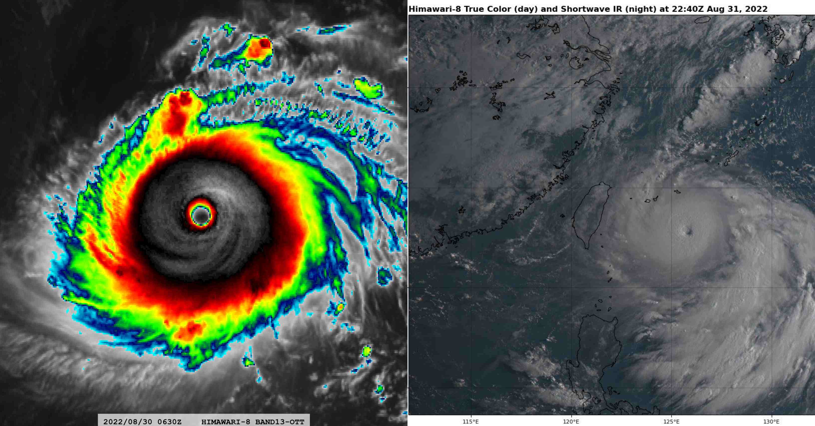
2.5-minute rapid scan #Himawari8 Infrared images showing Super Typhoon #Hinnamnor as it reached Category 5 intensity while approaching the island of Minamidaitōjima, Japan (station identifier ROMD): https://t.co/oPnRJDgHbY pic.twitter.com/zIkcWGDrEG
— UW-Madison CIMSS (@UWCIMSS) August 30, 2022
Affected regions
The Japan Meteorological Agency (JMA) mentioned that the storm is expected to advance towards regions of Southwestern Japan, Eastern China, and South Korea during the following days. According to weather.com, Hinnamnor is will continue to expand as it moves south of Okinawa on Friday.
As wind speeds continue to climb, it will approach Japan’s Sakishima Islands and Okinawa’s main island between Saturday and Sunday. Later, it will also pass Taiwan and the coast of mainland China.
The Fujiwhara Effect
Typhoon Hinnamnor illustrated a phenomenon as the Fujiwhara Effect. The typhoon pulled a weaker storm and controlled the weaker storm.
According to National Weather Service, the Fujiwhara Effect happens when two storms get close to one another to form a shared centre, driven the two storms to revolve around the central point. Afterward, if one of the storms is stronger than the other, the weaker one will likely break apart in this effect. If the storms are strong enough, they may join or past one another and continue on their course.
Typhoon Hinnamnor, a powerful hurricane moving toward Japan, demonstrated a phenomenon called the Fujiwhara Effect this week where it literally pulled in a weaker storm and overpowered it!
Check it out in the video below and read more about it here: https://t.co/o0VDNsFh8c pic.twitter.com/EQrSuKLFyT
— FOX Weather (@foxweather) September 3, 2022
Sources: Foxweather, Weather.gov, TheIndianEXPRESS, Geographyrealm, Firstpost, JMA